A winter storm watch is in effect in our area from Wednesday night through late Thursday night or early Friday morning.
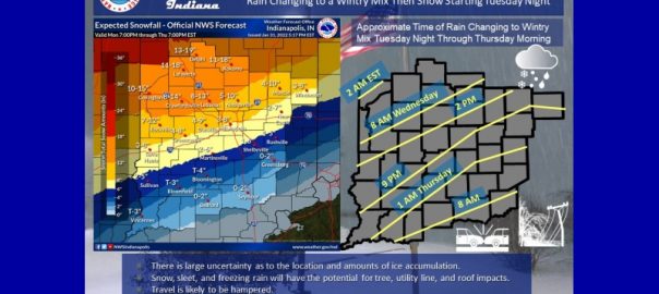
The National Weather Service in Indianapolis says affected area counties includes Bartholomew, Brown, Decatur, Jackson, Jennings, and Johnson counties. Heavy mixed precipitation is expected with snow accumulations of 4 to 8 inches in central and southern Indiana. Rain is expected to switch over to a wintery mix in southern Indiana early Thursday morning.
The agency says snow, sleet and freezing rain will have the potential to damage trees, utility lines and roofs.
The National Weather Service is warning that travel could be very difficult. And you can expect hazardous conditions during your morning commute.
Forecasters are saying that there is a great deal of uncertainty still on where the storm will hit and the exact timing. At least 90-million people are in the path of heavy snow, ice, and bitter cold.