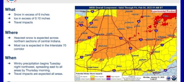
The National Weather Service says a new blast of winter weather is about to leave several more states shivering, with the largest impact hitting central Indiana.
Freezing rain and ice are expected to hit from Missouri into Indiana, Illinois, Ohio and Michigan Tuesday through Thursday. The Indianapolis office says there is a high level of uncertainty on where the storm will hit. But our area is at the south end of a band crossing central Indiana that could see major impacts.
Current forecasts would see rain Tuesday night into Wednesday night, with a wintry mix of snow, sleet and freezing rain possible as cold air moves in Thursday. You could see significant travel problems across the area.
The Bartholomew County Emergency Management Department warns that now is the time to prepare. Shannan Cooke, director of the office, says you should ensure that you have a full tank of gas in your vehicles. You should check to make sure your emergency kits are stocked and ready to go. And don’t forget to check the batteries in your weather radio and flash lights.
The next major storm moves in tomorrow, dumping snow on Colorado and New Mexico. A historic storm already hit the East Coast over the weekend, burying parts of Massachusetts in up to 30 inches of snow and leading to three deaths in New York.
TTWN Media Networks Inc. contributed to this story.


