Low-income area residents will have a chance for free legal advice next week.
River Valley Legal Aid and Pro Bono Indiana will be offering a walk-in legal clinic on Tuesday in Brown County. If you take part you will have a brief consultation with a volunteer attorney to answer general questions, to offer legal information or to receive other advice.
The session will focus on general legal advice on civil matters such as family law, guardianship powers of attorney, protective orders, simple wills and small estates.
The walk-in clinic will be from 3 to 5 p.m. Tuesday at the Brown County Public Library on Locust Lane.
River Valley Legal Aid offers the clinics for low-income residents of its eight-county district to receive legal advice and assistance. Residents of all area counties are invited to attend.
INDOT says that road projects in Shelby County will close two major state highways, one for a few weeks and one through October.
Starting yesterday, U.S. 52 is closing over Brandywine Creek in Shelby County for a bridge replacement project. The bridge is located just east of State Road 9 near Fountaintown.
U.S. 52 will be open to local traffic only, west of State Road 3 in Rushville. The official detour will follow State Road 9, U.S. 40 and State Road 3.
State Road 52 is expected to reopen in mid-October, weather permitting.
On Monday, May 12th, State Road 9 will close between Shelby County Road 850N and 750N for a structure replacement project in Shelby County. The structure is located approximately 6.8 miles north of I-74 in Shelbyville
The official detour will follow I-74, I-465, and U.S. 52.
State Road 9 is anticipated to reopen in early June.
The work schedules are dependent on the weather.
INDOT reminds you to slow down, to drive without distractions and to use extra caution in all work zones.
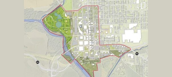
The next Columbus community survey is going live as planners continue working on the Downtown Columbus 2030 project.
The Downtown Columbus 2030 plan is meant to guide the city planners and developers in several specific areas. The plan will expand on previous efforts such as Envision Columbus, which was completed in 2018.
The efforts kicked off in November and the city has contracted with the Sasaki engineering firm from Boston and a financial firm from Chicago to take a fresh look at the city efforts to revitalize the area.
Several community workshops have been held and a previous survey was available.
Among the topics in this new survey, it offers questions on where in the downtown community members would like to see growth in housing, in office space, and hotel and hospitality development. It also is looking for your interest in increased retail, dining and entertainment in specific parts of downtown.
The survey will be available to the public through May 21st. You can find a link on the web at downtowncolumbus2030.com
The Seymour mayor’s office is looking for high school students to be members of the Mayor’s Youth Council.
The youth council operates as an advisory board to the mayor on issues affecting youth in the community. Council members take part in city meetings, tour city facilities, hear from guest speakers and participate in other leadership activities. Participants will need to agree to take part in youth council meetings up to twice a month through the school year.
May is Mental Health Awareness Month and the Bartholomew County community’s Mental Health Matters coalition is planning a full slate of activities to help reduce the stigma against mental health and to get people the help they need.
Organizers say that there are a wide range of free and low cost events schedule, ranging from support groups and wellness workshops to yoga sessions and a neighborhood block party.
There will be two pop-up events today, with one starting at The Commons at 3:30 p.m. and one at The Forge on 4th at 5:30 p.m. Vachel Hudson with the Mental Health Matters coalition will be on hand to answer questions and to share resources.
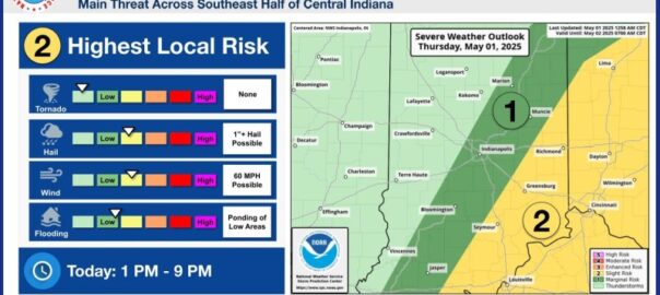
We could see some more severe weather this afternoon.
The National Weather Service puts much of southeastern Indiana under a slight risk for bad weather, following a diagonal line roughly from Seymour to Greensburg.
A cold front is expected to move through the area this afternoon bringing bad weather with it. We could see numerous thunderstorms this evening which could turn strong to severe. That could include hail of up to an inch, 60 mph winds and heavy rains bring flooding to low-lying areas. The greatest danger today will be from 1 p.m. this afternoon through 9 p.m. this evening.
Tornadoes are not expected with this storm.
Looking to the weekend, more thunderstorms are forecast for Friday and Saturday.
Indiana State Police recently recognized the Versailles District’s 2024 Trooper of the Year at an awards ceremony.
According to state police, Trooper Brian Weigel was chosen for the award. He is a two and a half year veteran of the state police. Last year he responded to more than 1,200 calls for service, had more than 800 traffic contacts, 97 criminal arrests, 20 DUI arrests and investigated 37 crashes.
His supervisor made the nomination, praising his attitude and work ethic. State police also recognized the good working relationships he has established with law enforcement, prosecutors, school personnel, and community leaders.
Weigel was the unanimous choice of the Versailles Post command staff to receive the award. The Versailles District includes Bartholomew, Decatur, Jackson, Jennings and six other south-central Indiana counties.
Weigel graduated from East Central high School, Vincennes University and Indiana University East. Before joining the state police in 2022, he previously served with the Dearborn County Sheriff’s Department, where he lives with his family. He was assigned to patrol Dearborn and Ripley counties.
2024 Trooper of the Year for the Versailles District Brian Weigel. Photo courtesy of Indiana State Police.
Talking Tombstones, a fundraiser for the Bartholomew County Historical Society and Columbus Parks Foundation, will be returning next week the Columbus city cemetery.
The Friday, May 9th event will feature actors taking on the roles of famous residents of the past who are buried in the cemetery. There will more than 20 stations you can visit at your own pace. The city cemetery is just south of Donner Park.
There will also be a food truck you can visit, located in the parking lot off of 19th Street.
It will start at 5:30 p.m. next Friday with entrance to the cemetery at 16th and 19th streets.
Tickets are $15 in advance or $20 the night of the event. You can get them through Eventbrite https://www.eventbrite.com/e/talking-tombstones-tickets-883833609117 at the Bartholomew County Historical Society museum on Third Street or at the event.
For more information you can call the historical society at 812-372-3541.
Photo courtesy of Bartholomew County Historical Society
Emiliano Cuevas-Bravo. Photo courtesy of Indiana State Police.
An 18-year-old is in custody, accused of firing a shot inside the Jackson County Public Library in Seymour, wounding one person
According to authorities, Seymour dispatchers received reports at just before noon yesterday that shots had been fired inside the library on Second Street. Seymour officers, along with Jackson County deputies, Indiana State Police and Indiana State Excise police arrived to find that a library patron had subdued 18-year-old Emiliano Cuevas-Bravo and was holding him down. He was taken into custody and is facing two counts of attempted murder, criminal recklessness with a deadly weapon and intimidation.
Indiana State Police say Cuevas-Bravo entered the building’s front entrance and opened fire with a long gun. One person was injured and those injuries are not believed to be life-threatening.
Cuevas-Bravo then went to the second floor of the library where he placed the gun on the floor. That’s when he was tackled by the library patron.
Sgt. Stephen Wheeles with the Indiana State Police said that they do not yet have a motive in the incident
Investigators contacted the Department of Homeland Security who confirmed Cuevas-Bravo is a U.S. citizen. And officers found that he is a student at Seymour High School.
Authorities say that before the incident at the library, Cuevas-Bravo, first went to the high school looking for a school resource officer, planning to target that officer. However he wasn’t able to find the officer and next went to the library.
Seymour police say that an item of concern was found at the library and members of Indiana State Police – Special Operations Section, Columbus Police Department, and FBI explosive disposal units responded, where they conducted operations on the concerning item.
Numerous items of evidence were collected from Cuevas-Bravo’s vehicle, along with items found inside the library.
Authorities say that Cuevas-Bravo appeared to act alone. Seymour police will have extra officers at schools today as a precaution.
According to a statement from the Jackson County Public Library, all library locations are closed at least through Saturday, May 3.
Sgt. Stephen Wheeles audio courtesy of Network Indiana.
Emiliano Cuevas-Bravo. Photo courtesy of Indiana State Police.
Seymour Man Arrested for Attempted Murder Following Shooting Inside Jackson County Library
This afternoon, April 30, 2025, a Seymour, Indiana man was arrested on two counts of attempted murder following a shooting inside the Jackson County Public Library in Seymour, Indiana.
The initial investigation by Seymour Police Detectives, Investigators with the Indiana State Police-Versailles Post, and Agents with the FBI-Indianapolis Field Office indicates that just prior to noon today, Emiliano Cuevas-Bravo, age 18, Seymour, Indiana entered the front entrance of the library. Immediately upon entering the library, he fired one shot from a long gun towards two employees working nearby, causing one employee to sustain non-life threatening injuries.
Cuevas-Bravo then went to the second floor of the library where he placed the gun on the floor. A patron of the library then tackled him and held him there for law enforcement officers. Seymour Police
Officers were on scene very quickly and took him into custody. Officers from the Indiana State Police, Jackson County Sheriff’s Department, and Indiana Excise Police were also on scene within minutes. The Columbus Police Department additionally provided valuable resources during the investigation.
Additional information gathered during the investigation indicated that Cuevas-Bravo went to Seymour High School earlier in the morning to initially target a Seymour Police Department School Resource Officer. Cuevas-Bravo never entered the school or made contact with the officer before he eventually left and went to the library.
Emiliano Cuevas-Bravo was arrested and incarcerated at the Jackson County Jail on preliminary charges of Attempted Murder-2 counts, Criminal Recklessness with a Deadly Weapon-1 count, and Intimidation-1 count. Cuevas-Bravo will soon face an initial hearing in the Jackson County Circuit Court.
The multi-agency investigation remains ongoing at this time. Investigators remained on scene throughout the afternoon.
Jackson County EMS and the Seymour Fire Department also assisted at the scene.
Earlier story:
Seymour Police Department responded to a shooting incident at the Jackson County Library today.
Few details are yet available, but dispatchers received a report at noon of an active shooting at the library in Seymour. Police responded and the shooter was taken into custody. City police were assisted at the scene by the Jackson County Sheriff’s Department, Indiana State Police and the Indiana Excise Police.
More information will be released as it becomes available.