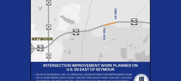
All posts by John Clark

Police crackdown on cell phone use starts on Saturday

Police will be looking for drivers with cell phones in hand or otherwise distracted during the “Put the Phone Away or Pay” enforcement blitz starting on Saturday.

State and local officers are taking part in the two week enforcement campaign which will run through April 19th. Officers will be looking for those driving while distracted, who are speeding or otherwise driving dangerously.

Officials say distracted driving and speeding caused more than 17,000 thousand crashes across Indiana last year, which led to 230 deaths.

The campaign is being funded by the National Highway Traffic Safety Administration with grants administered by the Indiana Criminal Justice Institute.

Emergency officials warn of possibly dangerous storms Wednesday

Emergency officials urge you to be prepared for two major rounds of bad weather on Wednesday.

Bartholomew County Emergency Management says that the first round of storms are expected tomorrow morning from 6 to noon bringing small hail and heavy rain. But the worst weather is expected to move through our area from 6 at night until 2 Thursday morning. Those storms are expected to bring straight line winds of 70 to 80 mph, large hail and flash flooding and possible tornadoes.

Heavy rain is expected to continue Thursday through Saturday. With the rain falling on already saturated ground, minor to moderate flooding is expected on area rivers and streams through the weekend.

Officials say that now is the time to prepare yourself. They say you should have multiple ways available to receive weather forecasts and alerts. They also warn that tornado sirens are meant to be heard outside and cannot be relied on if you are inside of a building.

You should have a location designated as your safe spot at home and at work. A basement or storm shelter is best, but an interior room, stairway or hall without a window or door to the outside is also acceptable.

Severe storms predicted Wednesday; Flood watch to be in effect

It looks like Wednesday could be another night for bad weather in our area.

The National Weather Service in Indianapolis forecasters say that we are going to have showers and thunderstorms Wednesday, turning to heavy rain and breezy by Wednesday night with severe weather possible. All of Indiana is under an enhanced risk of severe storms Wednesday night with wind gusts of more than 70 mph, flash flooding likely and tornadoes possible.

Very heavy rainfall is possible from late Wednesday through Saturday night due to multiple rounds of rain. Significant river flooding could develop late this week into the weekend, with runoff from the rain may lead to flooding of rivers, creeks, streams and other low-lying and flood prone locations.

The agency has issued a flood watch for central and southern Indiana starting Wednesday evening and lasting through Sunday morning. They suggest that those living in areas prone to flooding should be prepared to take action should flooding develop.

U.S. 31 closed at Bartholomew and Jackson county line

U.S. 31 is closed in southern Bartholomew County and northern Jackson County for a month and a half or more.

According to the Indiana Department of Transportation, contractors will be doing construction work on a bridge north of Reddington. That is between East Jackson County Road 1125N and East Bartholomew County Road County Road 900S. The road is expected to be closed until May 15th but the schedule is dependent on the weather.

INDOT reminds you to slow down, to drive without distractions and to be extra alert to worker safety in all work zones.

Road 800N closing today in Bartholomew County

Bartholomew County officials say that County Road 800N will be closing today.

According to the county highway department, 800N will be closed for road repairs between County Roads 50W and 200W, starting at about 8:30 a.m. and lasting until about 3:30 p.m. in the afternoon.

No thru traffic will be permitted while the work is going on.

Bartholomew deputy graduates from FBI National Academy

Bartholomew County Sheriff’s Department Capt. Chris Roberts. Photo courtesy of FBI National Academy

Capt. Chris Roberts with the Bartholomew County Sheriff’s Department recently graduated from the FBI National Academy.

Roberts is the captain of criminal investigations for Bartholomew County Sheriff’s Office.

Last week, 244 law enforcement officers graduated today from the FBI National Academy in Quantico, Virginia. The National Academy offers 10 weeks of advanced communication, leadership, and fitness training. Participants must have proven records as professionals within their agencies to attend.

Sheriff Chris Lane congratulated Roberts, saying that, as a previous graduate himself, he knows the “benefit of attending this academy and the quality of the instruction given to the attendees.”

Lane said Roberts will be an invaluable resource for the community for years to come

Two accused in Columbus residential burglary investigation

Dustin Harden. Photo courtesy of Columbus Police Department.

Two arrests have been made in a residential burglary last week in Columbus.

According to the Columbus Police Department, officer were called to 2200 block of Ohio Avenue about a burglary Wednesday. The homeowner was away when someone broke in and stole electronics and a shotgun. A video was recorded showing a suspect wearing pink joggers, a pink sweatshirt and a black coat.

Later, police were called to the 300 block of Cleveland Street about a person trespassing matching that description. Police found 20 year old Dustin Harden of Hope wearing the pink clothes. He was taken into custody and police discovered marijuana and smoking pipe near him. They also say he attempted to run away but was soon captured.

All of the stolen items were found after Harden’s arrest and police gathered information that 60-year-old Phillip Brantley of Columbus had the shotgun.

Harden is facing preliminary charges of:

  • Burglary
  • Resisting law enforcement
  • Possession of marijuana
  • Possession of paraphernalia
Phillip Brantley. Photo courtesy of Columbus Police Department

Brantley is being accused of:

  • Possession of a firearm by a serious violent felon
  • Obstruction of justice

Storm damage survey finds no tornado evidence

A preliminary survey of damage from Sunday’s storm in Bartholomew and neighboring counties shows that no tornado touched down in our area, however straight line wind damage did occur at nearly tornado speeds.

Local emergency officials and the National Weather Service inspected damage yesterday from Sunday nights storms that led to several tornado warnings. The survey included Bartholomew, Brown and Monroe counties. Damage in all three areas indicated damage caused by straight line winds of 65 to 85 mph.

Many photos and videos are circulating of rotating wall clouds or funnel clouds, and surveyors can not rule out that a brief, weak tornado could have touched down in an inaccessible area such as in heavy woods, or touched down but caused no noticeable damage.

The weather service says that the rotation did strengthen what they called the “rear flank downdraft wind” effect, or straight-line winds. Nearly all of the damage was caused to small or rotten trees that were either uprooted from soft ground of soft wood trees such as pine that appears to have snapped from swaying in the winds. Nearly all of the tree damage was isolated and surrounded by smaller trees or structures with received little or no damage.

They also said that in an area along Christianburg Road, in eastern Brown County several trees were snapped off near their tops, which could have been caused by rotation from a funnel cloud.

The weather service says that they are welcoming any more reports, photos or videos of damage and could revise this preliminary result if more information becomes available.

Photo: March 30th storm damage. Photo courtesy of Bartholomew County Sheriff’s Department.

Power remains out; Flood watch starts Wednesday

Hundreds of people in our area are still without power this afternoon after last night’s storms blew through.

Duke Energy is reporting about 700 customers without power from Nashville to Westport. That includes just under 500 in Columbus, 182 in western Bartholomew County near Grandview Lake and 20 near Nashville.

Bartholomew County REMC is reporting 324 customers without power this afternoon, most in Ohio Township on the west side of the county, centered around Grandview Lake. The local utility says this morning that the Grandview outage is going to require major repairs and will take significant time. They say that because the damage is so widespread, they are unable to backfeed many homes. You should plan for a prolonged outage in that area.

Columbus Police are warning that several traffic lights remained out as of early this afternoon.

According to Lt. Skylar Berry, spokesman for the police department, the traffic lights at N National Road/Central Avenue, N National Road/Westenedge Drive, and Rockyford Road/Central Avenue are still completely out.

Authorities say that if you are traveling through those intersections, you should drive carefully and expect delays.

It looks like Wednesday could be another night for bad weather in our area.

The National Weather Service in Indianapolis forecasters say that we are going to have showers and thunderstorms Wednesday, turning to heavy rain and breezy by Wednesday night. Very heavy rainfall is possible from late Wednesday through Saturday night due to multiple rounds of rain.

Flash flooding will be possible Wednesday night into Thursday with significant river flooding potentially developing late this week into the weekend.

The agency has issued a flood watch for central and southern Indiana starting Wednesday evening and lasting through Sunday morning. They say that excessive runoff from the rain may lead to flooding of rivers, creeks, streams and other low-lying and flood prone locations.

They suggest that those living in areas prone to flooding should be prepared to take action should flooding develop.

Deadline Wednesday to sign up for job readiness workshops

The deadline is coming up Wednesday to register for the next sessions of the Bartholomew County Works job readiness training workshop.

The next day-long workshop series will start on Monday April 7th and run through Friday April 11th at Yes Cinema.

An orientation session will be held on Thursday from 10 to 11:30 a.m. in the morning.

To get more information on signing up, you can call Lincoln-Central Neighborhood Family Center at 812-378-2638.