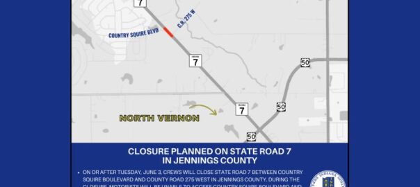
All posts by John Clark

Rivers and streams threaten moderate flooding into weekend

Rivers and streams in our area will see significant flooding by this weekend, even before adding in more rain that is expected over the next few days.

According to estimates from river gauges East Fork White River and its tributaries will see moderate to near major flooding by Sunday. Flat Rock River at Columbus and Driftwood River near Edinburgh are expected to go into minor flooding by early Saturday morning. Flat Rock River is forecast to crest at just inches below the moderate flood level by Sunday while Driftwood River should crest in the moderate flood stage by early Monday.

Haw Creek in Hope is expected to enter into the minor flood stage any time now.

East Fork White River in Columbus should enter the minor flood stage by early Saturday morning and crest at about a foot and half below the moderate flood stage by Sunday morning. In Seymour, East Fork White River should enter the minor flood stage this afternoon and crest about a foot above the moderate flood stage by Sunday morning.

Muscatatuck River at Vernon is forecast to crest just above the minor flood stage by Friday morning.

Forecasters are still expecting between three and three quarters of an inch to more than six inches of additional rain by Saturday evening which will add to those river levels or extend the length of the flooding.

More thunderstorms are forecast Friday into Saturday with some possibly severe. Damaging winds and large hail are the primary threats.

You can keep up to date on the flooding and other weather on our website here: https://1010wcsi.com/weather-forecast/#flooding

Power outages affect thousands in our area

Note: This story has been updated

Power companies are reporting a string of outages in our area due to last night’s strong storms with more than 9,000 customers without power.

According to Duke Energy, nearly 6 thousand customer are without power in our area. That includes nearly 4 thousand in Jackson County stretching from 3 thousand in Seymour, nearly 700 near Brownstown and 467 in Medora. The North Vernon area is showing more than 2 thousand without power, while in Bartholomew County there are 152 customers without power in the Grandview Lake area on the west side of the county. Only a single Duke Energy customer in Columbus itself is without power.

Bartholomew County REMC is reporting 10 customers without power

Jackson County REMC is reporting more than 2 thousand customers without power in its coverage area including more than 200 near Norman Station and more than 1,000 in and around Salem.

Southeastern Indiana REMC has just over 900 customers affected by power outages this morning

This total estimate is down from about 15,000 earlier this morning.

Johnson County REMC is reporting no customers without power this morning.

Heavy rain runoff causing flooding concerns today

Flood warnings are in place in our area, both in the short term and in the longer outlook.

The National Weather Service has replaced a flash flood warning that went into effect early this morning with a flood warning until 9 this morning for low-lying and flood prone areas.. That warning is in effect for Bartholomew, Johnson and Shelby counties until 9 this morning. During the strong storms overnight areas received between an inch and a half to three inches of rain.

Kyle Mounce meteorologist with the WRTV Storm Team explains the flooding situation.

A flood warning also remains in effect for local rivers and streams through Sunday morning.

Louisville & Indiana railroad repairs to close local streets

Crews will be closing Columbus railroad crossings over the next few weeks.

According to Legacy Excavating, the contractor for the project on the Louisville and Indiana Railroad tracks, the company will be making crossing repairs in the Columbus area. Company officials say they recognize that the closings may cause some inconvenience and seek your understanding and cooperation. They say you should plan accordingly and use an alternate route if necessary.

The first closings happen next week including South Hinman Street, South of Vermont Street on Tuesday; South Beatty Lane south of Georgia Street on Wednesday and South Mapleton south of Wolf Street on Thursday.

Other upcoming crossings include:

  • South Gladstone Ave  north of Kreutzer Drive on Tuesday, April 15th.
  • South Marr Road  east of South Gladstone Ave and south of Roadway Drive on Wednesday, April 16th

The crossings are expected to be closed from 6 to 6 each day.

The contractors are also announcing an overnight closing just west of the intersection of 3rd and Lindsey Streets on Saturday, April 12th. That will be from 9 p.m. Saturday to 9 a.m. Sunday. This closure will affect all westbound SR46 traffic and all southbound Jonesville Road traffic.

The work schedule is dependent on the weather.

Rally set for Saturday to protest Trump administration actions

A local group will be holding a rally on the steps of Columbus City Hall on Saturday to protest the actions of the Trump Administration.

Organizers with Columbus Community United plan to rally at City Hall at noon on Saturday as part of a “Hands Off! National Mobilization to Fight Back.” According to the groups’ announcement, the effort is meant as a “message to the world that we do not consent to the destruction of our government and our economy for the benefit of Trump and his billionaire allies.”

The organizers say that the Hands Off movement is committed to non-violence and hope to de-escalate any potential confrontations with those who may disagree.

You can find a link for more information here:

Window for severe weather moves later tonight

Note: This story has been updated

3:50 p.m. update

The Columbus Municipal Airport terminal building will be available for those who need to shelter from tonight’s severe weather. City officials say that you should make sure any pets are secured and that you bring only essential items.

The terminal is at 4770 Ray Boll Boulevard.

In Hope, residents in need of shelter can go to the basement of Hope United Methodist Church, according to the Hope Police Department.

3:45 p.m. update

According to Bartholomew County Emergency Management:

Multiple periods of thunderstorms are expected  through Saturday night.

All severe weather hazards are possible tonight with the most likely time for dangerous tornadoes coming from 5 to 9 p.m. There is also the likelihood of damaging straight line winds with gusts of 70 – 80 mph, 1 to 2 inch diameter hail and flash flooding caused by 1 to 3 inches of rainfall. Supercells could potentially form ahead of a line in the late afternoon and evening including the potential for a few strong (EF2+) tornadoes.

After 9 p.m., damaging wind/flooding then becomes the primary threat, with an isolated tornado threat into the evening and overnight as the main line moves through.

3:21 p.m. update

Forecasters say our area is under a moderate risk of severe weather today with heavy rains, high winds and tornadoes possible this evening.

Kyle Mounce meteorologist with the WRTV Storm Team explains the risk we are seeing.

A wind advisory is in effect from now until 1 tomorrow morning with south winds of 20 to 30 mph and gusts of up to 50 mph expected. A flood watch is in effect from 8 tonight through Sunday. A flood warning goes into effect on Driftwood River starting Friday night with moderate flooding expected or worse depending on the amount of rainfall we get.

New Columbus police officer sworn in Tuesday

Officer Allen Cummings

The Columbus Police Department is welcoming its newest officer.

Allen Cummings was sworn in Tuesday by Mayor Mary Ferdon. He attended Columbus North High School and joined the U.S. Army, where he served as a combat medic and on tank maintenance. He served six years in the service, before returning to Columbus with this family. He now serves in the Army Reserves as a military police officer.

Cummings will be undergoing training with department instructors and will leave to attend the Indiana Law Enforcement Academy in May.

Photos courtesy of Columbus Police Department.

Forecasters confirm small tornado from Sunday storms

Authorities are confirming that a tornado touched down in Ripley County during Sunday night’s bad weather.

The National Weather Service in Wilmington Ohio, says that an EF-0 tornado touched down near Napoleon at about 7:54 in the evening and ended about two minutes later. Storm damage surveyors say the tornado traveled about two miles on the ground damaging trees and homes. Wind speeds are estimated at 80 mph.

The same storm system caused wind damage in Bartholomew, Brown and Monroe counties and witnesses saw rotation and a possible funnel cloud in western Columbus but surveyors could not find any evidence that a tornado touched down.

Area under risk of severe storm danger tonight; Flooding continues into weekend

Emergency officials urge you to be prepared for two major rounds of bad weather today.

Forecasters say our area is under a moderate risk of severe weather today with heavy rains, flash flooding, high winds and tornadoes all possible. The first round of storms are expected this morning bringing small hail and heavy rain. But the worst weather is expected to move through our area after 4 p.m. this afternoon through 3 a.m. in the morning Thursday. That weather could be severe.

A wind advisory is in effect from 8 a.m. this morning until 1 p.m. tomorrow morning with south winds of 20 to 30 mph and gusts of up to 50 mph expected.

Heavy rain is expected to continue Thursday through Saturday. With the rain falling on already saturated ground, minor to moderate flooding is expected on area rivers and streams through the weekend. A flood watch is in effect from 8 p.m. tonight through Sunday.

Officials say that you should have multiple ways available to receive weather forecasts and alerts. They also warn that tornado sirens are meant to be heard outside and cannot be relied on if you are inside of a building.

You should have a location designated as your safe spot at home and at work. A basement or storm shelter is best, but an interior room, stairway or hall without a window or door to the outside is also acceptable.

A wind advisory is in effect from 8 this morning until 1 tomorrow morning with south winds of 20 to 30 mph and gusts of up to 50 mph expected. A flood watch is in effect from 8 tonight through Sunday.

Career fair Wednesday at Columbus Learning Center

There will be a career fair Wednesday at the Columbus Airpark Campus at the Columbus Municipal Airport.

Students and community members are invited to talk with local employers.

The career fair will be from 1 to 3:30 p.m. in the Columbus Learning Center on Central Avenue. Rachel Hunt with the Community Education Coalition explains;

Organizers say that this is a chance to connect with employers from a variety of industries, explore job and internship opportunities, and network with professionals. Dozens of local businesses will be present and looking for employees.

They say you should be sure to bring your resume and dress in professional attire.

The career fair is being presented by IU Columbus, Ivy Tech Community College Columbus Campus, Purdue Polytechnic and the Columbus Education Coalition