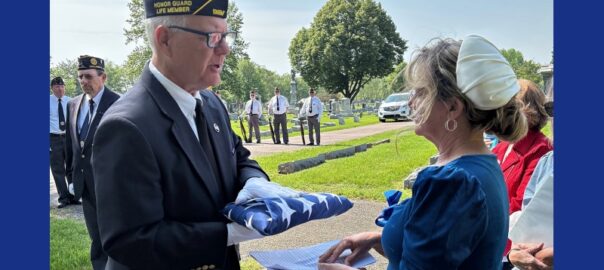
All posts by John Clark

Columbus spring cleanup to haul away yard waste starting Monday

The city of Columbus will be holding its annual spring clean up starting on Monday. You will be able to prepare your yard for spring planting and get rid of any remaining fall leaves or other yard waste.

On your designated trash day you can put leaves, grass clippings, and pine needles curbside, where it will be picked up by city vacuum cleaners. Those materials can not include

  • Dirt or sod
  • Mulch or rocks
  • Decorative grasses
  • Sticks or branches
  • Trash or recycling of any kind.

If you do have sticks or branches to get rid of, you should put them in a separate pile and they will be picked up for the chipper.

The program runs Monday through April 25th.

For more information you can go here: https://www.columbus.in.gov/public-works/2024/03/28/2024-spring-clean-up/

Roads closed due to high water in Bartholomew County

Bartholomew County Emergency Management says that some roads that are impassible after Wednesday night’s storms and heavy rain.

According to the agency, as of last night roads closed by high water include

  • Enon Rd, between SR9 and N 700 E
  • Sunland Rd/225 N
  • 930 S, between 300 W and 400W
  • 600 E, south of 850 S to Jennings/Jackson Co line

In Columbus, the south side of Mill Race Park and Noblitt Park are both closed by high water.

Authorities urge you not to attempt to drive through high water over the roadway. Especially in the dark, it is impossible to judge how deep the water is or the condition of the roadway underneath.

The National Weather Service says six inches of moving water is enough to knock adults off their feet,  a foot of water can sweep away a car and two feet can carry off an SUV or pickup. They urge you to turn around and don’t drown.

East Fork White River rising to major flood in Seymour, moderate in Columbus.

Forecasters now are expecting major and moderate flooding along some rivers in our area, starting today

The National Weather Service in Indianapolis upgraded its flood warning for our area from moderate to major flooding along the East Fork White in Seymour and downstream, and issued warnings of moderate flooding for East Fork White River at Columbus, Flatrock River in Columbus, Driftwood River at Edinburgh, Muscatatuck River at Vernon and Big Blue River in Shelbyville among others.

Forecasters say we received one to three inches of rain Wednesday and are now expecting up to seven more inches of rain through Sunday. Excessive runoff may result in flooding of rivers, creeks, streams, and other low-lying and flood-prone locations.

East Fork White River in Seymour entered the minor flood stage yesterday afternoon and will be going into moderate flooding this morning. Major flooding is expected to start by Sunday morning and will crest at 19.5 feet by Sunday evening, inches above the major flood stage. That is about a foot and a half below record levels.

In Columbus, East Fork White River is expected to enter the minor flood stage by this afternoon and go into moderate flooding by Sunday morning. The river is expected to crest Sunday evening just over a foot above the moderate flood stage and just under a foot below the major flooding level.

You can find more information on flooding on our website here: https://1010wcsi.com/weather-forecast/#flooding

Power companies work to restore electricity after Wednesday storms

Power companies are still reporting outages in our area due to last night’s strong storms with more than 3,500 customers without power this afternoon.

According to Duke Energy, more than 600 customers are without power this afternoon. That includes 250 in the Jackson County and northern Scott County area and 250 around North Vernon

Jackson County REMC is reporting more than 2,500 customers without power in its coverage area including more than 200 near Norman Station and Heltonville and more than 2,000 in and around Salem.

Southeastern Indiana REMC has just over 100 customers affected by power outages this afternoon.

Bartholomew County REMC is reporting no customers without power this afternoon.

Major flooding now expected in Seymour, moderate flooding in Columbus

Forecasters now are expecting major and moderate flooding along some rivers in our area, starting by Friday.

The National Weather Service in Indianapolis upgraded its flood warning for our area from moderate to major flooding along the East Fork White in Seymour and downstream, and issued warnings of moderate flooding for East Fork White River in Columbus, Flatrock River in Columbus, Driftwood River in Edinburgh, Muscatatuck River in Vernon and Big Blue River at Shelbyville in our area.

Forecasters say we received one to three inches of rain Wednesday and are now expecting five to seven more inches of rain through Sunday morning.

East Fork White River in Seymour will be entering the minor flood stage this afternoon and going into moderate flooding by Saturday morning. Major flooding is expected to start by Sunday morning and will crest at 19.4 feet, inches above the major flood stage and about a foot and a half below record levels by Sunday evening.

In Columbus, East Fork White River is expected to enter the minor flood stage by Friday afternoon and go into moderate flooding by Sunday morning. The river is expected to crest Sunday evening just over a foot above the moderate flood stage and just under a foot below the major flooding level by Sunday evening.

Flatrock River in Columbus is expected to enter the minor flood stage by Friday morning and the moderate flood stage by Friday afternoon. It should crest just about half a foot above the moderate flood stage by early Monday morning.

Haw Creek in East Columbus is about two feet below the minor flood stage this afternoon. No estimate is available on its future level but it has already been on its way down near Clifford, where it has since dropped back below the minor flood stage and the action stage.

Driftwood River near Edinburgh is expected to enter the minor flood stage by early Friday morning and the moderate flood stage by Saturday morning. It should crest in the moderate flood stage by Monday afternoon.

Big Blue River at Shelbyville is expected to enter the minor flood stage by Saturday morning and the moderate flood stage by Saturday evening. It should crest in the moderate flood stage by Sunday morning.

In Vernon, the Muscatatuck River is expected to go into the minor flood stage overnight Saturday and to crest in the minor flood stage by Sunday morning before heading back down.

The National Weather Service says most of our area is under a slight risk of severe weather tonight, but more southern parts of the state, including parts of Jackson and Jennings counties are under a more dangerous moderate risk. The main danger is flash flooding.

Forecasters say there is a chance of heavy rainfall later today, with up to an inch more of rain on the already saturated soil. Showers and thunderstorms are likely after 7 p.m. tonight.

Forecasters warn of heavy rain, thunderstorms today increasing flooding

We could see another wave of bad weather today.

The National Weather Service says most of our area is under a slight risk of severe weather, but more southern parts of the state, including parts of Jackson and Jennings counties are under a more dangerous moderate risk. The main danger is flash flooding.

Forecasters say there is a chance of heavy rainfall later today, with up to an inch more of rain on the already saturated soil. Thunderstorms are likely after 7 p.m tonight.

Most of Indiana is under a marginal risk of heavy rain and flooding late Friday and Friday night.

Cummins announces new chief administrative officer

Nicole Lamb-Hale. Photo courtesy of Cummins.

Cummins is announcing that Nicole Y. Lamb-Hale will be its new Chief Administrative Officer and Corporate Secretary.

The Columbus based engine manufacturer said yesterday that Lamb-Hale will replace Sharon Barner when she retires on May 31.

Prior to joining Cummins in 2021 as Vice President and Chief Legal Officer, Lamb-Hale held executive leadership roles at Kroll, LLC, a global risk advisory firm, and Albright Stonebridge Group, a global strategic advisory and commercial diplomacy firm. She previously served as Assistant Secretary for Manufacturing and Services in the U.S. Department of Commerce’s International Trade Administration under President Obama.

In her new role, she will oversee functions such as risk management, ethics and compliance, product compliance and regulatory affairs, government relations, communications and corporate responsibility.

High water closing many local roads

A long list of local roads and streets are closed due to high water, downed trees and limbs or fallen power lines.

As of 5:10 a.m., the Bartholomew County Emergency Management Department reports the following roads closed:

  • 750 S from Hillview to 750 W
  • 750 W from 750 S to 700 S
  • 400 W from Deaver Rd to Somerset Ln
  • 580 W, between 50 N and Old Nashville Rd
  • 675 W, north of SR46
  • 475 W, between Carr Hill Rd and 250 S
  • SR46 at Belmont Dr
  • Marr Rd at 15th St
  • Mill Race south side
  • Noblitt Park
  • Central Ave, at Parkside Dr

Water on Roadway:

  • Wolfcreek Rd has water rising, but still passable
  • SR11, south of Circle K – Water on roadway, but still passable
  • 250 S, at 475W – high water, but passable

Trees Down / Wires Down:

  • 11061 W Grandview Dr – Tree and Wires Down in Roadway, but passable.
  • 11311 W Grandview Dr – Tree in roadway. Road passable for 1 vehicle.
  • 675 W / 50N – Tree and Wires Down in roadway.

Emergency officials urge you not to drive into water over roadways. They say you should turn around and don’t drown.

Rivers and streams threaten moderate flooding into weekend

Rivers and streams in our area will see significant flooding by this weekend, even before adding in more rain that is expected over the next few days.

According to estimates from river gauges East Fork White River and its tributaries will see moderate to near major flooding by Sunday. Flat Rock River at Columbus and Driftwood River near Edinburgh are expected to go into minor flooding by early Saturday morning. Flat Rock River is forecast to crest at just inches below the moderate flood level by Sunday while Driftwood River should crest in the moderate flood stage by early Monday.

Haw Creek in Hope is expected to enter into the minor flood stage any time now.

East Fork White River in Columbus should enter the minor flood stage by early Saturday morning and crest at about a foot and half below the moderate flood stage by Sunday morning. In Seymour, East Fork White River should enter the minor flood stage this afternoon and crest about a foot above the moderate flood stage by Sunday morning.

Muscatatuck River at Vernon is forecast to crest just above the minor flood stage by Friday morning.

Forecasters are still expecting between three and three quarters of an inch to more than six inches of additional rain by Saturday evening which will add to those river levels or extend the length of the flooding.

More thunderstorms are forecast Friday into Saturday with some possibly severe. Damaging winds and large hail are the primary threats.

You can keep up to date on the flooding and other weather on our website here: https://1010wcsi.com/weather-forecast/#flooding