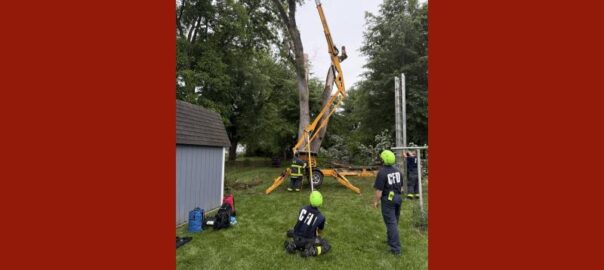
All posts by John Clark

Weekend flooding among highest in area history

The National Weather Service says that this weekend’s major floods in Columbus, Seymour and Shelbyville are some of the highest in history.

According to the agency, the 17.09 foot crest level on East Fork White River at Columbus was the third highest of all time and the highest since the June 2008 flood.

At Seymour, the 19.78 flood crest on East Fork White River was also the third highest in history and the highest since 2008.

The Big Blue River at Shelbyville crested at 19.98 feet, the second highest ever since the March 1913 flood.

Other high water records set during this flooding (courtesy of the National Weather Service/NOAA via Columbus Planning Department):

Driftwood River (USGS Gage at Edinburgh):
Crest – 16.57 feet on Sunday, April 6 at 4:30 p.m.
This is the 4th highest recorded crest on the Driftwood.
This was a 10-year flood event (10-year elevation: 15.7 feet / 50-year elevation: 17.3 feet).
Record Crest – 20.30 feet on March 28, 1913.
Flatrock River (USGS Gage at Columbus):
Crest – 16.22 feet on Sunday, April 6 at 9:15 a.m.
This is the 3rd highest recorded crest on the Flatrock.
This was a 10-year flood event (10-year elevation: 16.1 feet / 50-year elevation: 17.9 feet).
Record Crest – 19.94 feet on June 7, 2008.
East Fork White River (USGS Gage at Columbus):
Crest – 17.09 feet on Sunday, April 6 at 5:15 p.m.
This is the 3rd highest recorded crest on the White River.
This was a 10-year flood event (10-year elevation: 15.4 feet / 50-year elevation: 18.7 feet).
Record Crest – 18.61 feet on June 8, 2008.
Haw Creek (USGS Gage at Clifford):
Crest – 14.07 feet on Saturday, April 5 at 11:45 a.m.
This is the 7th highest recorded crest on Haw Creek.
This approached a 50-year flood event (10-year elevation: 13.5 feet / 50-year elevation: 14.2 feet).
Record Crest – 17 feet on June 7, 2008.
Clifty Creek (USGS Gage at Columbus):
Crest – 19.56 feet on Sunday, April 6 at 1:15 a.m.
This is the 4th highest recorded crest on Clifty Creek.
This was a 10-year flood event (10-year elevation: 19.2 feet / 50-year elevation: 21.1 feet)
Record Crest – 22.17 feet on June 7, 2008.
Photo: Flooding on State Road 46 looking east on Sunday, April 6th. Photo courtesy of Columbus Fire Department.

Rivers returning to normal levels after major flooding: 1:30 p.m. update

Note: This story has been updated

Flood waters on rivers and streams in our area continue to fall in Columbus, with flood waters dropping down to minor flood levels this morning on East Fork White River.

According to river gauges, East Fork White River has fallen below the moderate flood stage of 14 feet and is now in the minor flood stage. This afternoon the river was at 12 feet, about two feet below the moderate flood stage. It is expected to drop back below the 9 foot minor stage by tomorrow morning.

In Seymour, East Fork White River has dropped out of major flooding. This afternoon the river is at 18.7 feet, that is about 2.5 inches below the major flood stage. The river isn’t expected to drop below moderate flooding until Wednesday afternoon. It should drop completely below minor flooding by Friday afternoon.

Flooding on other area rivers is also heading back down. Driftwood River at Edinburgh has now dropped to the minor flood stage. Flat Rock River at Columbus has now dropped below the minor flood stage. Minor flooding continues on Sugar Creek near Edinburgh.

Photo: Flooding on State Road 46 in west Columbus on Sunday, April 6th. Photo courtesy of Columbus Fire Department.

Jennings jail officer facing charges after dispute involving gunshots

Harlan Pennycuff. Photo courtesy of Jennings County Sheriff’s Department.

A Jennings County Jail officer was arrested after a fight and gunshots Friday night near Butlerville.

According to the Jennings County Sheriff’s Department, several people called to report an accident between an ATV and a car and a dispute between the drivers. Witnesses reported that a man was on the hood of the vehicle, trying to prevent the car from leaving. While deputies were on their way, shots were reportedly fired at the scene.

Deputies arrived to find a car parked in a lot with the female driver waiting for police to arrive. Based on her report and lack of damage, deputies concluded there was no evidence a collision has actually happened. They also found that the man who climbed onto her vehicle’s hood had pulled a gun and fired several shots into the ground.

26-year-old Harlan Pennycuff of North Vernon was arrested on charges including criminal confinement, pointing a firearm and criminal recklessness with a deadly weapon.

The sheriff’s department also said he was immediately fired from his job as a jail officer.

Bartholomew County roads closed: 3 p.m. Monday update

Note: This story will be updated as more information becomes available.

Bartholomew County Emergency Management has released a list of roads closed due to high water. According to the agency.

Roads Closed:

  • Entrance/Exit Ramps I-65 at 68 MM (SR 46)
  • SR 46 both directions Goeller to SR 11
  • Carr Hill Rd, between Jonathan Moore Pike (SR46) and Morgan Willow
  • SR 11 south of the overpass
  • Southern Crossing, east of SR11 (Jonesville Rd)
  • SR 11, between 650S and 800S
  • 800 S, east of SR11
  • Lowell Rd, between 250 W and 325 W
  • Georgetown Rd, W of 325 W
  • 325 W, between Lowell Rd and Carlos Folger Rd
  • 150 E by Southern Crossing
  • 250 S, between 400 and 475 W
  • 50 N, between 600 W and 675 W
  • Tellman Rd/200 W to Indianapolis Rd
  • 200 N between 500 W/325 W
  • 10043 N 330 W
  • Riverside Dr, beind the Lagoons
  • 330 W, north of 450 N and North of Ohio Ridge Rd
  • 300 E/600 S
  • Double Y Saddle Club
  • SR 58/Spray Rd
  • 550 W/Spray Rd
  • 900 N, between 300 E and 200 E
  • 600 E/850 S
  • Water Street
  • 100 N/200 W to Indianapolis Rd
  • Indianapolis Rd/Arcadia (s of Arcadia)
  • 3700 Blk N 250 W
  • Tannehill Rd (W 650 N)/330 W to Driftwood Bridge
  • 340 E, between Azalia and 650 S
  • 7590 N 330W- just pass this address
  • S Gladstone (S Curves) to 300 S and 150 E

High Water:

  • 550 N, between 100 W and 50 W (one lane open)
  • Henry Lakes Blvd to US 31
  • Indianapolis/Carl Miske
  • Golden Maize Dr
  • 800 N/Base Rd

Parks:

  • Mill Race South Side
  • Noblitt Park
  • Clifty Park
  • People Trails
  • Mccullough Run Park

Photo courtesy of Columbus Police Department

Patchy fog possible this morning; Freezing temperatures tonight

Forecasters say that it could be foggy out there this morning and it is expected to get cold again tonight.

The National Weather Service is warning of spots of patchy dense fog this morning. Visibility could be less than a quarter of a mile or less in some places. You should make sure to slow down and give yourself extra time to reach your destination.

The fog should dissipate by 10 a.m. this morning.

In addition to a freeze warning last night, the weather service is warning of freezing temperatures again tonight. Forecasters say it could be as low as 25 tonight. A freeze warning is in effect from 1 a.m. until 10 a.m. Tuesday morning.

Downstream residents warned as Youth Camp dam leaks

In addition to the ongoing river flooding in our area, Bartholomew County officials are also warning of a flash flooding threat at the dam near Youth Camp Road.

Shannan Cooke, head of Emergency Management for the county explained that the dam is leaking and a pump is currently working to help pump water levels from the lake down and reduce pressure on the dam.

Cooke said Youth Camp is following their emergency plan. That includes notifying residents, and calling for a Flash Flood Watch downstream from the dam on Wolf Creek.

Cooke said the watch gives residents downstream area a heads up to prepare for evacuation.

The flash flood watch remains in effect until at least Tuesday morning.

Aerial photo courtesy of Bartholomew County GIS system

Flood warnings continue; Many roads remain closed

Much of our area remains under flood warnings this morning as major flooding continues along East Fork White River and moderate flooding on other rivers and streams.

East Fork White River appears to have crested this morning and is heading back down to the lower moderate flood level.

In Columbus, East Fork White River is at 16.8 feet this morning, down from a crest of just over 17 feet yesterday afternoon. That was more than a foot and a half below the record flood level of 2008. The river should drop back to moderate flooding in Columbus by this afternoon.

At Seymour, the river is at 19 and a half feet this morning, that is still about six inches above the major flood stage. The river crested at 19.78 feet, about a foot and a quarter below the record flood level of 21 feet set in the 2008 flood. The river at Seymour is not expected to drop back to moderate flooding until Tuesday morning.

Other rivers remain in moderate flooding, including Flatrock River at Columbus, Driftwood River and Sugar Creek at Edinburgh.

Haw Creek and Clifty Creek have both returned to normal levels.

Major roads and streets remain closed while the water remains high and until crews can clean up debris left behind. In Bartholomew County, State Road 46/Jonathan Moore Pike from Lindsey Street downtown to Goeller Boulevard on the west side is expected to remain closed until tonight, including the ramps at Interstate 65. Also expected to remain closed are State Road 11 from Jonathan Moore Pike to Walesboro and Southern Crossing.

Many other secondary roads and streets also remain closed. Officials warn that you should not drive around barricades or road closing signs. Their message is to turn around and don’t drown.

Authorities urge you not to drive into floodwaters over roadway

Emergency officials are stressing that you should not drive around high-water barricades or road closing signs.

Rescue workers in area counties have had to perform many water rescues over the weekend after drivers found themselves trapped after driving into floodwaters.

Toby Ortman, head of the Jackson County Emergency Management office explains that you are not just putting yourself at risk.

Bartholomew County Sheriff Chris Lane said yesterday that the county swift water rescue team had also been on two weekend calls to rescue those in homeless encampments trapped by the flood waters.

Photo courtesy of Bartholomew County Sheriff’s Department

Bartholomew government offices closed; Columbus services continue despite flooding

Bartholomew County has closed government offices today due to the ongoing flooding. The County Commissioners meeting is normally scheduled for 10 a.m. on Monday mornings but the plan now is to reschedule for later in the week.

The city of Columbus is keeping its offices open today. Mayor Mary Ferdon said essential services will remain fully operational. That will include trash and recycling routes, which will run on their normal schedule today, however you can expect delays.

Columbus Transit will also be running its normal routes, however Route 5 to the west side will not be running today due to the high water along the normal route.

Ferdon encouraged local businesses to be flexible to staff whose travel to work could be affected by the many closed roads and streets. She said that safety remains the community’s top concern.

Columbus Regional Health says that its facilities and services are all continuing as normal today. The hospital did put up flood gates on Saturday that were installed after the 2008 flood, however they were lowered again after Haw Creek waters receded.

Photo courtesy of Columbus Police Department

Bartholomew officials warn major roads closed through Monday

Bartholomew County emergency officials are warning that major roads will remain closed at least until Monday evening.

The county says that State Road 46/Jonathan Moore Pike from Lindsey Street downtown to Goeller Boulevard on the west side will remain closed, including the ramps at Interstate 65. Also expected to remain closed are State Road 11 from Jonathan Moore Pike to Walesboro and Southern Crossing.

As of Sunday afternoon, East Fork White River in Columbus is at 17.02 feet, about a foot over the major flood stage and near the predicted crest. But water levels aren’t expected to drop back below the moderate flood level until Monday morning, according to river gauge predictions.

East Fork White River at Seymour is also near its predicted crest at 19.78 feet with major flooding Sunday afternoon. It isn’t expected to drop back below moderate flooding until Tuesday morning.

Big Blue River at Shelbyville also continues major flooding but it appears to have crested at 19.98 feet earlier today, 22 tenths of a foot below the 20.2 record flood level. It is not expected to drop back to moderate flood levels until early Monday morning

Other area rivers remain in moderate flooding including:

    • Flatrock River at Columbus: Moderate flooding at 16.2 feet, 1.2 feet above the moderate flood level of 15 feet. The river is expected to crest this afternoon in the moderate flood stage.
    • Flatrock River at Rushville: Moderate flooding at 15.01 feet, .1 feet above the moderate flood stage. The river has already crested and is expected to return to minor flooding momentarily.
    • Driftwood River at Edinburgh: Moderate flooding at 16.56 feet, 2.5 feet above the moderate flood level. The river is expected to crest momentarily.
    • Sugar Creek at Edinburgh: Moderate flooding at 16.51 feet, 2.5 feet above the moderate flood level. The river is expected to have crested in the moderate flood stage.

Haw Creek is no longer flooding at Hope, Clifford or Columbus. Clifty Creek is also no longer flooding. Muscatatuck River at Vernon never reached the minor flood stage.

Bartholomew Consolidated Schools and Whitecreek Lutheran school will be closed Monday and have declared an elearning day.

Authorities have also announced a freeze watch for our area overnight, with temperatures as low as 23 possible.

Photo courtesy of Columbus Police and Fire departments.