Forecasters say that we could see some severe weather this afternoon and evening.
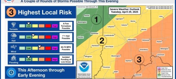
According to the National Weather Service, southeastern Indiana is under an enhanced risk of severe storms this afternoon and evening as a cold front moves through. That is expected to bring thunderstorms with strong winds and damaging hail with areas of heavy rainfall.
We could see wind gusts as high as 70 mph with 1 inch hail a few tornados possible in our area.
Emergency officials say you should use extra caution while driving because strong winds could make it hard to control vehicles, especially those with high profiles. Winds could be strong enough to knock down limbs or trees and power lines.
Also a reminder that central and southern Indiana weather radios are out of commission today. The outage is expected to last through at least Wednesday, however it could go as long as Thursday or Friday while the channels go through a mandatory system upgrade.
Emergency officials say that you should make sure you have several ways to receive emergency weather notifications while the radio system is down. In Bartholomew County, you can sign up for the Everbridge alert system. You can also use the Federal Emergency Management Agency’s or American Red Cross mobile apps, and listen to local news stations.