Monthly Archives: March 2025

Power remains out; Flood watch starts Wednesday

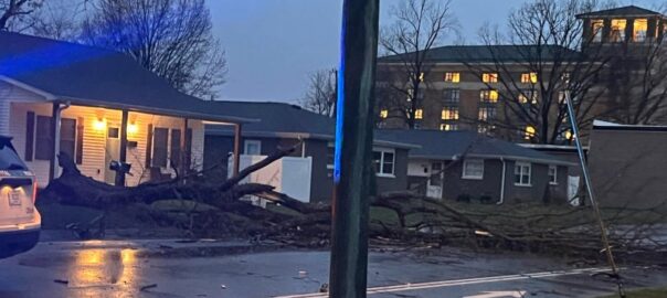
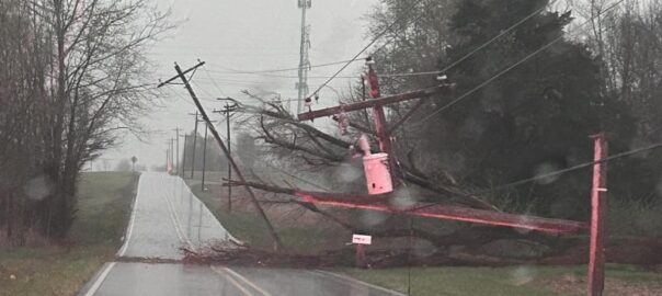
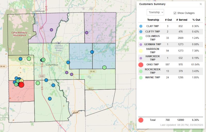
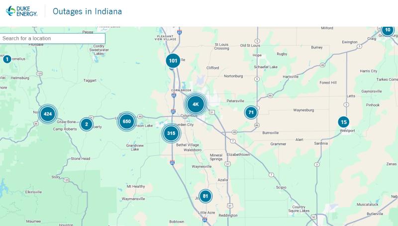
Hundreds of people in our area are still without power this afternoon after last night’s storms blew through.

Duke Energy is reporting about 700 customers without power from Nashville to Westport. That includes just under 500 in Columbus, 182 in western Bartholomew County near Grandview Lake and 20 near Nashville.

Bartholomew County REMC is reporting 324 customers without power this afternoon, most in Ohio Township on the west side of the county, centered around Grandview Lake. The local utility says this morning that the Grandview outage is going to require major repairs and will take significant time. They say that because the damage is so widespread, they are unable to backfeed many homes. You should plan for a prolonged outage in that area.

Columbus Police are warning that several traffic lights remained out as of early this afternoon.

According to Lt. Skylar Berry, spokesman for the police department, the traffic lights at N National Road/Central Avenue, N National Road/Westenedge Drive, and Rockyford Road/Central Avenue are still completely out.

Authorities say that if you are traveling through those intersections, you should drive carefully and expect delays.

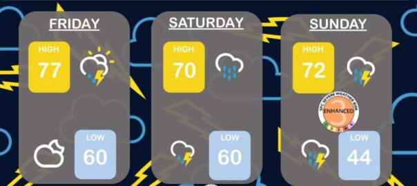
It looks like Wednesday could be another night for bad weather in our area.

The National Weather Service in Indianapolis forecasters say that we are going to have showers and thunderstorms Wednesday, turning to heavy rain and breezy by Wednesday night. Very heavy rainfall is possible from late Wednesday through Saturday night due to multiple rounds of rain.

Flash flooding will be possible Wednesday night into Thursday with significant river flooding potentially developing late this week into the weekend.

The agency has issued a flood watch for central and southern Indiana starting Wednesday evening and lasting through Sunday morning. They say that excessive runoff from the rain may lead to flooding of rivers, creeks, streams and other low-lying and flood prone locations.

They suggest that those living in areas prone to flooding should be prepared to take action should flooding develop.

Deadline Wednesday to sign up for job readiness workshops

The deadline is coming up Wednesday to register for the next sessions of the Bartholomew County Works job readiness training workshop.

The next day-long workshop series will start on Monday April 7th and run through Friday April 11th at Yes Cinema.

An orientation session will be held on Thursday from 10 to 11:30 a.m. in the morning.

To get more information on signing up, you can call Lincoln-Central Neighborhood Family Center at 812-378-2638.

Columbus recycling center to celebrate Earth Day April 26th

The Bartholomew County Solid Waste Management District will be celebrating Earth Day next month with events at the Bartholomew County and Columbus Recycling Center on Mapleton.

Earth Day events will be happening from 8 to 3 on Friday April 26th.

There will be an amnesty day to get rid of hard-to-dispose-of waste. You can turn in up to two refrigerant containing appliances, up to two propane tanks, up to four tires from personal vehicles, with the rims removed. All of those are at no cost.

There will be educational displays including the Bartholomew County Public Library Book Express, the Bartholomew County RC Flyers, Sans Souci and the Columbus Department of Public Works.

Bartholomew County residents can pick up a free pickup load of mulch or compost from 8 to 12. There will be residential document-shredding from 9 to 11 a.m..

There will also be plant swap and a tree giveaway. Toyota Material Handling is sponsoring the tree event and there will be tulips and redbuds given away.

The event is for Bartholomew County residents only. Out of county residents and businesses can not participate. You can get more information at bcswmd.com.

Applications open for senior, special needs grants to non-profits

Applications are now open for grants to organizations helping those with special needs through the Voelz, Reed, & Mount Foundation

Heritage Fund: The Bartholomew County Community Foundation says that the grant applications are open to nonprofit organizations in Bartholomew, Jackson, Jennings and Decatur counties that serve aging adults and those with special needs. The grants will go to support projects and programs that have a positive impact on the lives of senior citizens, those with special needs and their families and will range from $500 to $1,500 each.

Voelz, Reed, & Mount are attorneys specializing in estate and elder law in Columbus and Central Indiana. The local law firm partnered with Heritage Fund in 2022 to establish a business foundation to give back to the communities where they do business. Since then, the foundation has awarded more than $25,000 in grants.

The deadline for organizations to apply is May 2nd. You can get more information at https://www.heritagefundbc.org/grants.

Thrive Alliance planning memorial pickleball tourney

Thrive Alliance will be hosting a pickleball tournament in May named in honor of local pickleball player Bill Martin.

Martin died in 2022 from Alzheimer’s. Organizers say that even after his diagnosis, Martin continued to support and cheer on pickleball players. All proceeds for the tournament will go to support the agency’s Dementia and Care Partners Programming. The programs work to keep people engaged in their communities and offer support and respite care to their care partners.

The tournament will be Saturday, May 3rd and will be held on the 18 pickleball courts at CERA Sports Park. There will be a round robin scramble format tournament across five divisions ranging from beginner to advanced. There will be a maximum of 16 players per division.

The cost to play is $40 per person. You can find links to register on our website.

Crews search for damage, make repairs from Sunday night storms

Note: This story has been updated

Bartholomew County emergency officials will be out looking for signs of a possible tornado last night in the community.

Shannan Cooke, head of the county’s Emergency Management Department, says that there were several unofficial reports of a funnel cloud on the west side of the county, near the Interstate 65 and Jonathan Moore Pike intersection.

Tornado warnings were issued for Bartholomew County at 7:08 p.m. and again at 7:29 p.m. last night according to the National Weather Service, both showing radar indicated rotation in the storms.

Cooke says the county has been added to those that can report damage from last night’s storms. You are encouraged to visit in211.org and click on DAMAGE REPORTING to submit a report. You can also dial 211 or 866-211-9966, Monday – Friday, 7 a.m. to 7 p.m. to complete a damage report over the phone.

Thousands of people in our area are still without power this morning after last night’s storms blew through.

Duke Energy is reporting about 1,100 customers without power from Nashville to Westport. That includes more than 775 in Columbus, more than 300 in western Bartholomew County near Grandview Lake and 121 near Nashville.

Bartholomew County REMC is reporting 802 customers without power this morning, most in Ohio Township on the west side of the county, centered around Grandview Lake. The local utility says this morning that the Grandview outage is going to require major repairs and will take significant time. They say that because the damage is so widespread, they are unable to backfeed many homes. You should plan for a prolonged outage in that area.

Bartholomew County REMC will have mutual aid and contractor crews coming in this morning.

Local emergency officials say that you should stay out of the way or repair and cleanup crews from last night’s severe storms in our area. Authorities urge you to stay off the roads if you can, and if you have to be out to use extra caution while they work through the problem areas.

The strong winds knocked down trees and power poles blocking many local roads and streets. With continuing power outages, you could still see traffic snarled with some traffic lights out. You should be on the lookout for temporary traffic signals or officers directing traffic.

According to Bartholomew County Emergency Management, as of this morning several roads remain closed with power lines down including:

  • 300 S/ 650 W
  • 650 W/ 450 S 250 E in between State St and 275 S
  • 550 W in between Nasby Trail and Deaver Rd
  • 300 S/ 475 W
  • The stop lights at National/Westenedge are out. Officers are present directing traffic.

As of last night, the Bartholomew County Emergency Management Department had three reports of trees or poles that fell on houses in Columbus, Grandview Lake area and Sunnybrook Trailer Park in Elizabethtown.

No injuries have been reported.

Photo: Storm damage near Columbus Regional Hospital Sunday night. Photo courtesy of Tom Kotowski.

Trees and powerlines down; thousands without power

Note: This story will be updated as more information becomes available.

10:20 p.m.

Bartholomew County Emergency Management Director Shannan Cooke says the county has been added to those that can report damage from tonight’s storms. You are encouraged to  visit in211.org  and  click on DAMAGE REPORTING to submit a report. You can also dial 211 or 866-211-9966, Monday – Friday, 7 a.m. to 7 p.m. to complete a damage report over the phone.

Columbus Police spokesman Lt. Skyler Berry reports that their officers have been dealing with trees and lines down, some are still in the roadway. There were several traffic lights out due to power outages.

“We encourage anyone who has to travel to do so carefully. If you can, stay home and allow crews to clean up,” Berry said.

10:15 p.m.

Duke Energy is reporting nearly 5,000 customers without power in our area including 3,000 in the Columbus area, another 757 in western Bartholomew County, 444 in Nashville, 145 near Jonesville, 73 near Petersville,  51 near Brownstown, 15 near Westport and 30 near Greensburg at of 10:10 p.m.

Bartholomew County REMC is reporting 899 customers without power, most in Ohio Township.

Jackson County REMC is reporting 1,147 without power in its coverage area, including 453 near Crothersville, 30 near Brownstown and more than 300 near South Bethany.

10:10 p.m. update

According to Bartholomew County Emergency Management, they have heard reports of a possible funnel cloud sighted on the west side of Columbus near the Interstate 65/Jonathan Moore Pike area during tonight’s storms. However, that information has not yet been confirmed. Tomorrow morning, crews will be out surveying damage, looking for signs of possible tornado activity.

Shannan Cooke, director of Bartholomew County Emergency Management, said there are multiple trees and power lines down across the county.  She said she has seen three reports of trees that have or poles that have fallen on houses in Columbus, Grandview Lake area and Sunnybrook Trailer Park in Elizabethtown.  No injuries have been reported.

8:35 p.m. update

Bartholomew County REMC is reporting 768 customers without power, most in Ohio Township.

Jackson County REMC is reporting hundreds without power in its coverage area, including 342 near North Vernon, 30 near Brownstown and more than 300 near South Bethany.

Southeastern Indiana REMC is reporting 142 customers without power in its area.

Johnson County REMC is reporting no current outages.

8:30 p.m. update

Thousands of people in our area are without power in the wake of severe storms this evening.

Duke Energy is reporting nearly more than 5,000 customers without power including 4,000 in the Columbus area, another 765 in western Bartholomew County, 426 in Nashville, 81 near Jonesville, 71 near Burnsville,  51 near Brownstown and 465 near Medora as of 8:26 p.m.

8:20 p.m. update

Bartholomew County Emergency Management says that there are trees and power lines down block roads at multiple locations.

They urge you to stay off the roads and to allow crews time to clean up the debris and damage from the storms.

Tornado warnings were issued for Bartholomew County at 7:08 p.m. and again at 7:29 p.m. according to the National Weather Service.

Storm damage photo courtesy of Bartholomew County Sheriff’s Department


Tornado watch in effect until 8 p.m. Sunday

The National Weather Service in Indianapolis has issued a tornado watch that is in effect for our area.

Area counties affected include Bartholomew, Johnson, Shelby and Brown counties. Other affected counties include Boone, Carroll, Clay, Clinton, Davies, Fountain, Greene, Hamilton, Hancock, Hendricks, Henry, Howard, Knox, Lawrence, Marion, Martin, Monroe, Montgomery, Morgan, Owen, Parke, Putnam, Rush, Sullivan, Tippecanoe, Tipton, Vermillion, Vigo and Warren.

From the Bartholomew County Emergency Management Department:

The county remains under an Enhanced Risk for severe weather and Marginal Risk for flash flooding today. Another round of severe weather is expected Wednesday, April 2nd. Multiple rounds of rainfall Thursday through Saturday may lead to flooding. We will continue to monitor and update as necessary.

Key Messages:

  • Enhanced Risk for severe weather Sunday.
  • Marginal Risk for flash flooding Sunday.
  • Expected timing of the severe threat is about 2 PM to 11 PM.
  • Could see multiple rounds of storms through some areas.
  • Greater chance of supercell development south of Indianapolis.
  • Localized flooding is possible Sunday afternoon and evening with the storms.
  • Another round of severe weather expected Wednesday, April 2nd.
  • Heavy rain possible.
  • Extent of severe weather threat still in question. Confidence is increasing.
  • Isolated flooding today with more widespread flooding later in the week as additional rounds of heavy rain and thunderstorms impact the area.

Timing:

  • Sunday – 2 PM to 11 PM
  • Primarily between 2 PM and 8 PM for Bartholomew County, but can occur anytime between 2 PM and 11 PM..
  • Wednesday – Exact timing still in question.

Main Threats:

  • Damaging wind gusts – 70 to 80 + mph. Please note these winds can still do the same damage as an EF0 or EF1 tornado, so do not let your guard down.
  • Isolated tornadoes.
  • Large hail – 1 to 2”+.
  • Localized flooding possible – storm total rainfall as high as 0.5” to 1.0”+.

Actions/What To Do:

  • Be weather aware.
  • Have multiple ways to receive warnings. Two to three ways are recommended.
  • Remember, tornado sirens are meant to alert people outdoors.
  • Know where to shelter within your home or place of work.
  • If you live in a mobile home, it’s recommended to seek shelter with family or friends in a more durable structure, prior to the storms.
  • Ensure flashlights and radios have fresh batteries and cell phones are charged.
  • Use caution when driving. Strong winds can make driving difficult and cause high profile vehicles to overturn.
  • Strong winds can cause downed trees and power lines that may be difficult to see in the dark.
  • Do not drive through moving or standing water. If you can’t see the road, turn around.

Windy today but also very warm; Severe weather possible Sunday

Forecaster say we are looking at some windy, wet days but also unseasonably warm.

The National Weather Service in Indianapolis says we are in for some windy weather today, with regular gusts of up to 40 mph possible. The winds will be strong enough to blow around anything left outside and we could see tree limbs knocked down and some power outages this afternoon.

Temperatures through the weekend will be unseasonably warm, with possibly a record high today.

Showers and thunderstorms are likely all weekend, with an enhanced risk of severe weather Sunday night.

Cummins’ Accelera, Isuzu to unveil new electric powertrain at April show

Cummins’ Accelera brand is announcing that they will unveil a battery electric powertrain for the Isuzu medium duty truck line at an upcoming trade show.

Accelera is the zero-emissions business segment of Cummins, the Columbus based engine manufacturer. The partnership with Isuzu Motors Limited will lead to the new powerline for the F-series trucks in 2027, the companies said today. Accelera says that the powertrain will offer customers what they call “an innovative and versatile solution to fleet decarbonization.”

The powertrain will include Accelera’s next-generation battery, eAxle, accessories and controls

Shaun Skinner, President and CEO of Isuzu Commercial Truck of America, Inc., said in a statement that the addition will have the added benefit of “creating a localized supply chain and assembly capabilities (that) adds to our ability to meet customer demand.”

Accelera and Isuzu will offer the powertrain specifically for the F-series in the North American market. The components and their integration will be on display at the ACT Expo tradeshow in Anaheim, CA, from April 28th to May 1st.

You can find more information here: https://investor.cummins.com/news/detail/676/accelera-to-unveil-zero-emissions-integrated-battery